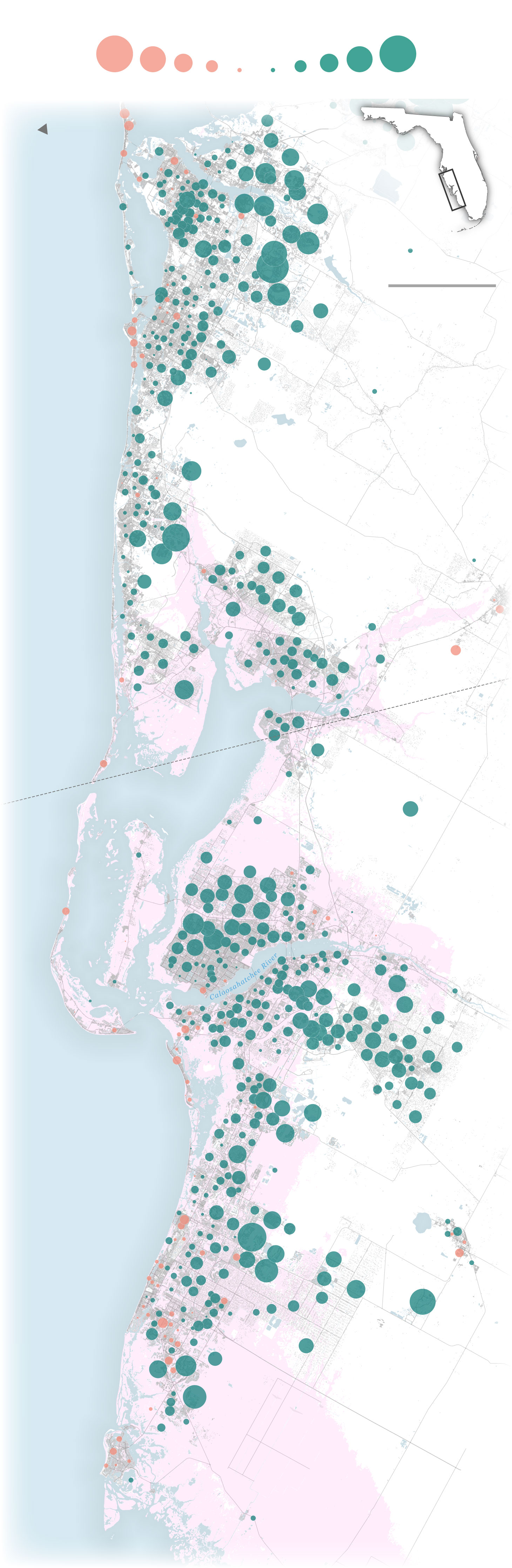
Net population change by census tract, 2010-2020
Growth
Decline
-10,000
5,000
2,500
1,000
-100
+100
1,000
2,500
5,000
+10,000
+1,013
-644
N
-304
FL
+2,219
Bradenton
+348
+3,173
+7,844
10 miles
Sarasota
-558
Siesta Key
Gulf
of
Mexico
+1,757
The North Port–Sarasota–Bradenton
metropolitan statistical area grew 19% from
2010 to 2020, adding about 130,000 people.
Venice
+2,417
Pink shading represents
areas that were at risk for
flooding during Hurricane Ian.
+5,684
+1,073
North Port
+1,160
Port Charlotte
-158
+2,711
Punta Gorda
Hurricane Ian’s path →
+1,206
Charlotte Harbor
+986
+1,118
+536
Pine Island
-372
Together, the cities of Cape Coral
and Fort Myers grew by about
65,000 people from 2010 to 2020.
+3,269
Cape Coral
Fort Myers
+2,017
Sanibel Island
Fort Myers
Beach
-479
+2,252
+662
Bonita Springs
Gulf
of
Mexico
+2,303
+928
Naples
+4,979
+1,438
+4,090
-328
Marco Island
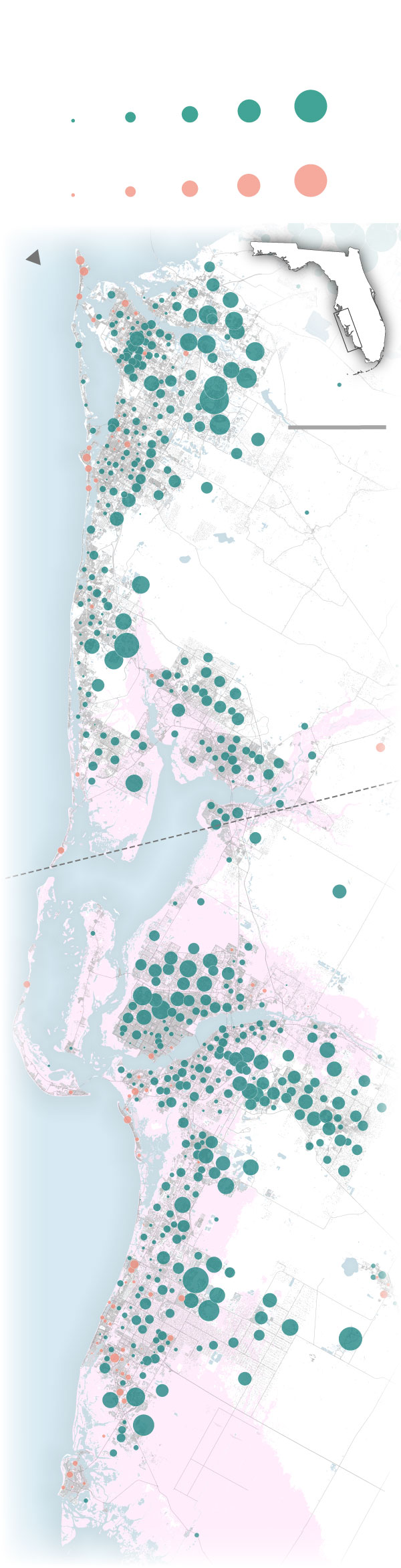
Net population change by census tract, 2010-2020
Growth
1,000
2,500
5,000
+10,000
+100
Decline
-100
1,000
2,500
5,000
-10,000
N
-644
FL
+2,219
Bradenton
+348
+3,173
+7,844
10 miles
Sarasota
-558
The North Port–Sarasota
–Bradenton metropolitan
statistical area grew 19%
from 2010 to 2020, adding
about 130,000 people.
Gulf
of
Mexico
+2,824
Venice
Pink shading represents
areas that were at risk for
flooding during Hurricane Ian.
North Port
+1,160
Port Charlotte
-158
+2,711
Punta Gorda
Hurricane Ian’s path →
+1,206
Together, the cities of Cape
Coral and Fort Myers grew by about
65,000 people from 2010 to 2020.
Pine Island
-372
Cape Coral
Fort Myers
+2,155
+2,017
Sanibel Island
Fort Myers
Beach
+2,252
Gulf
of
Mexico
Bonita Springs
+2,303
-617
+928
+4,979
Naples
+1,438
+4,090
-328
Marco Island